Water cliche alert.
The former mayor of Phoenix wants to see desalination plants lining the Sea of Cortez to supply future water needs in Northern Mexico and Southern Arizona because he says "water is going to become, if it’s not already, more valuable than gold or oil.” Apparently the economy is humming along so nicely in Phoenix they believe they are going to be the next Saudi Arabia. Why Saudi Arabia? Because that is the only place I know of relying heavily on desalinated water for municipal and industrial (M&I) needs (it may have something to do with the cheap cost of power in that region). If you're talking about using desal to supply irrigation water (which is where most of the water is used within areas that border the Sea of Cortez) you are in similarly sparse company. Israel and Spain are about the only places currently using desalinated water for irrigation on anything resembling a large scale and much of that use involves treatment of brackish groundwater rather than seawater. Those types of waters have a much lower dissolved mineral content than seawater, so production costs are also much lower, but it still isn't cheap water.
Showing posts with label Colorado River. Show all posts
Showing posts with label Colorado River. Show all posts
Monday, December 16, 2013


Monday, September 16, 2013
Might be time to try a little forebearance
I've been too busy to post anything on the recent announcement by Reclamation that a shortage declaration on the lower Colorado River is likely by 2016. But when I spotted this (pdf) on the agenda for the most recent board meeting of the Central Arizona Project, it seemed like a good time to chime in.
The fallowing and forebearance agreement between CAP and the Yuma Mesa Irrigation and Drainage District (YMIDD) is a first step to developing a relationship between water users in Arizona along the River and in the Central part of the state to try to forestall shortages to CAP customers.
The fallowing and forebearance agreement between CAP and the Yuma Mesa Irrigation and Drainage District (YMIDD) is a first step to developing a relationship between water users in Arizona along the River and in the Central part of the state to try to forestall shortages to CAP customers.
Tuesday, July 9, 2013
Group Dedicated to Restoring Glen Canyon Wants More Water in Lake Mead and Less in Lake Powell
This article was sent to me in an email earlier this week. As you might have guessed from the headline, I think their plan is a little self-serving. That's not to say it is clearly without merit. I don't have access to the study their conclusion is based on, but I would be very interested to read it.
I agree that seepage into the Navajo sandstone that borders the lake could soak up a significant amount of water stored there, but wouldn't much of what enters the rock during high water periods later exit the rock when the water is low? Admittedly, some of that water would be bound up in the rock matrix over time, but once that matrix porosity has been filled it can't be refilled again. So in some sense, the damage has been done and won't be undone by changing the management strategy of the reservoir. But I would like to see the data and calculations or models that were employed to get a better sense of how they reached their conclusions.
I agree that seepage into the Navajo sandstone that borders the lake could soak up a significant amount of water stored there, but wouldn't much of what enters the rock during high water periods later exit the rock when the water is low? Admittedly, some of that water would be bound up in the rock matrix over time, but once that matrix porosity has been filled it can't be refilled again. So in some sense, the damage has been done and won't be undone by changing the management strategy of the reservoir. But I would like to see the data and calculations or models that were employed to get a better sense of how they reached their conclusions.
Saturday, April 13, 2013
Yumans shoot down Water Augmentation plans
Way back in 2010 the Arizona state legislature, responding to widespread concerns that the state would run out of water in the future, created a study commission called the Water Resources Development Commission (WRDC). They set to work studying current and projected water demands, available water supplies, and the institutions in place that try to match up the two sides of the equation.
Friday, March 8, 2013
Some overdue follow-up
I've neglected to follow through on my promise to provide an update to the Arizona Dept. of Water Resources (ADWR) Non-Indian Agricultural (NIA) water re-allocation process, that I have previously discussed here and here. Sure I waited until almost the last minute but I am keeping my promise. ADWR did release their final process (pdf) for carrying out the water allocation last month, as they promised and they are having a meeting next week (3/12) to go over the rules with potential applicants. I won't be at the meeting because I don't represent any potential applicants - Indian tribes are specifically excluded from receiving an allocation of this water - but I hope to keep track of how this program progresses. The final process is not dramatically different from what they originally proposed. Without having parsed the final document closely the only real difference I can come up with is that they shifted some of the water to the second phase of allocation. Apparently there was some concern that the full amount they proposed to give away next year might not actually be contracted for under the set of qualifications they proposed. Maybe there will be some movement toward market allocation of water by the time the second phase starts up in 2021. Maybe.
The other item at ADWR I have been following is their proposal to modify certain aspects of the recharge program, which I previously discussed here. This proposal was floated by the department as a possible idea to include in the upcoming 4th Management Plans (4MP) for the Active Management Areas (AMAs). There has been pretty widespread acknowledgment for more than a decade that certain aspects of the regulatory regime that governs use of groundwater in the AMAs probably still permits too much groundwater pumping in certain areas to protect the overall health of the state's aquifers. ADWR thought they might try to address this by making some changes to the recharge program that would encourage water users to do their recharging and recovery of that recharged water in closer proximity. My point has been that the problem is not the proximity (or lack thereof) of recharging and recovery activities. The problem is that the rules simply allow too much pumping, sometimes in places where we might like to see a lot less pumping. I think something along these lines will show up in the 4MP, but it will just be a recommendation to study the issue further. This will result in a stakeholder process to look at possible solutions. I actually thought the current Safe Yield Task Force was supposed to be looking at this issue but maybe too many people involved are aware that the real solution is not a path they want to go down. We'll see.
The other item at ADWR I have been following is their proposal to modify certain aspects of the recharge program, which I previously discussed here. This proposal was floated by the department as a possible idea to include in the upcoming 4th Management Plans (4MP) for the Active Management Areas (AMAs). There has been pretty widespread acknowledgment for more than a decade that certain aspects of the regulatory regime that governs use of groundwater in the AMAs probably still permits too much groundwater pumping in certain areas to protect the overall health of the state's aquifers. ADWR thought they might try to address this by making some changes to the recharge program that would encourage water users to do their recharging and recovery of that recharged water in closer proximity. My point has been that the problem is not the proximity (or lack thereof) of recharging and recovery activities. The problem is that the rules simply allow too much pumping, sometimes in places where we might like to see a lot less pumping. I think something along these lines will show up in the 4MP, but it will just be a recommendation to study the issue further. This will result in a stakeholder process to look at possible solutions. I actually thought the current Safe Yield Task Force was supposed to be looking at this issue but maybe too many people involved are aware that the real solution is not a path they want to go down. We'll see.
Wednesday, January 23, 2013
Well ... maybe
I found a link to this story on Aquafornia this morning and was intrigued enough to read the article - even though I was skeptical. Obviously the first thing that jumps out at you is the title - "Watering fields in California boosts rainfall in Southwest". Makes you think that someone has possibly confirmed a link between the two. But then you read the first line in the story and that claim is qualified with "a new computer simulation suggests." So it turns out that using an appropriately scaled atmospheric circulation model and making some assumptions about excess evaporation occurring in the Central Valley of California in the summer it appears it just might be possible that some of the summer thunderstorms over the southwest could be modestly enhanced by said excess evaporation.
Sunday, January 6, 2013
Can Reclamation Change its Ways?
There has been lots of chatter in the blogosphere and elsewhere about the recently released Colorado River Basin Water Supply and Demand Study from the Bureau of Reclamation (BOR). This really is a ground-breaking study in many ways: it enshrines the likelihood that climate change is likely to have an impact on water supplies in the basin in the future; it acknowledges that the lower basin is already out of kilter in the supply vs. demand equation, and is highly dependent on deliveries of excess water from the upper basin to continue meeting that demand; and probably biggest of all, it largely acknowledges that the era of large public works projects to address water needs is probably over.
Tuesday, October 23, 2012
Cato Article - Downsizing the Federal Govt. - BuRec
There's definitely some Cato Institute stuff that's just too far out there for me, but when they take on federal control of water resources in the West and advocate for more use of markets to allocate a scarce resource, they can probably reel me in. I enjoyed this article, mostly for its advocacy of water markets. I think it's easy to find examples of where the federal government has screwed up in their long-standing management of Western water and they do a good job of chronicling those in the article. But they largely overlook much of the good that has resulted from those efforts - the Colorado being a prime example of both the good and bad of what the Bureau has done.
We would not have the infrastructure that is needed to weather extremes of climate, like we have been experiencing the last couple of decades in the Colorado basin were it not for the extensive infrastructure built by the Bureau and that infrastructure could not have been built by any smaller unit of government. We also could probably be figuring out better ways to manage the water of the basin if it weren't for ongoing federal control of the basin and all that infrastructure. But the Southwest that we currently have - good and bad - clearly wouldn't be around today if not for what the Bureau did with the Colorado.
And the article clearly does a much better job of chronicling what's wrong than of proposing workable solutions. That's think-tank work for you. But still a pretty good article if you swing toward the free-market side on water management.
hat-tip to Marginal Revolution for the link that eventually led me to this article.
We would not have the infrastructure that is needed to weather extremes of climate, like we have been experiencing the last couple of decades in the Colorado basin were it not for the extensive infrastructure built by the Bureau and that infrastructure could not have been built by any smaller unit of government. We also could probably be figuring out better ways to manage the water of the basin if it weren't for ongoing federal control of the basin and all that infrastructure. But the Southwest that we currently have - good and bad - clearly wouldn't be around today if not for what the Bureau did with the Colorado.
And the article clearly does a much better job of chronicling what's wrong than of proposing workable solutions. That's think-tank work for you. But still a pretty good article if you swing toward the free-market side on water management.
hat-tip to Marginal Revolution for the link that eventually led me to this article.
Friday, January 7, 2011
1 foot of elevation - could mean 80,000 acre-feet or 320,000 acre-feet
There have been a few news articles recently (i.e. here and here) about an announcement by Central Arizona Project (CAP, interestingly there's no mention of the idea on the CAP website) that they are considering leaving a portion of their allocation of Colorado River water in Lake Mead this coming year in an effort to maintain a higher lake level and hopefully avoid the potential for a declaration of shortage.
How does this work, you might ask? Part of the agreement from 2007 that allocated who will bear the brunt of shortages on the river also included some complex rules for what is called Intentionally Created Surplus (ICS). The general idea is that the lower basin states could develop arrangements whereby water that they don't really need in a given year - usually by engaging in some activity that actually conserves water that would have been used, i.e. fallowing farmland for a year - is left in Lake Mead, to be withdrawn in some future year. I don't know if Arizona's actions are considered ICS because nothing extraordinary is being done to save this water - it's basically water that Arizona doesn't currently need and for various reasons it might make more sense to leave it in Mead rather than pump it into the canal. But California entities (MWD) have taken advantage of this arrangement in the past. Arizona - or more specifically, the CAP - has not. CAP has been doing everything it can to take all its water.
Here's a little background. Arizona is allocated 2.8 million acre-feet (MAF) from the Colorado. 1.6 MAF goes to the CAP and the rest is used generally along the river for irrigation. But the thing is, entities that contract for CAP water don't currently need 1.6 MAF - so much of that water is put in the ground for storage, to be pumped out at a later date, like when there is a shortage on the river. Here is how the 2010 uses of CAP water break down, according to documents on their website:
- 2010 scheduled subcontract deliveries – 425,000 ac ft (this is mostly the water that is used by cities)
- 2010 scheduled deliveries to agriculture (technically excess water, but specifically allocated to the Ag pool) – 400,000 ac ft
- Other excess scheduled deliveries (includes deliveries for firming*; water purchased to offset pumping; probably some water purchased, taken and used directly for industrial purposes; and water purchased and recharged for generation of credits by private entities) – 474,000 ac ft
- Deliveries to Indian reservations (primarily Ag uses) – 104,000 ac ft
- Deliveries of Indian water for off-reservation uses (mostly recharge and leases to non-tribal entities) – 240,000 ac ft
- this adds up to slightly more than 1.6 MAF because some of the water delivered was water previously stored that was recovered (pumped out of ground) and delivered
By leaving this water in Lake Mead this year, Arizona hopes to 1) forestall a declaration of shortage and 2) make that water available to be taken out of the river in a future year when the reservoir storage is higher. This strategy makes a lot of sense for several reasons.
1) The water will hopefully be available in the future.
2) The in-state entity that handles most of the firming for the state (by recharging excess water or using it to replace groundwater pumping that would otherwise happen to supply irrigation water) is the Arizona Water Banking Authority (AWBA), an entity created specifically to help the state take its full allocation of Colorado River water sooner than we could actually put it to use in more traditional ways. In past years the AWBA has been given money from state budgets to carry out those activities, but some of that money has been taken away, leaving them with a reduced ability to carry out that function. But the main reason it makes sense at this point is:
3) If it really looks like Lake Mead is heading for that magic elevation of 1075 ft Arizona stands to lose out on 320,000 ac ft of water from the Colorado, which is a whole lot worse than temporarily losing out on 80,000 ac ft.
The whole reason Arizona has been taking all that extra water and putting it in the ground in the Central parts of the state was because we knew that shortages were gonna come some day and it would be much better to be able to pump that water out of the ground in-state than try to get any additional water from the Colorado. We're last in line at that tap anyway. But that was a good strategy as long as the level of Lake Mead stayed high enough that we should be able to take our full allotment. When shortages are looming - possibly in the next 2 years - a new strategy is called for. That's when you try to limit your losses as best as you can.
But, looking at the snow pack in the upper basin, it may be a very good year for flows into Lake Powell, which means more water will flow down to Mead in the summer and possibly forestall that shortage a little longer. We'll see.
updated 1/8/11 for content and clarity
Saturday, December 4, 2010
On the rise
Lake Mead is finally beginning to climb - see projection graph.
This was supposed to start happening a month ago, but ... better late than never.
This was supposed to start happening a month ago, but ... better late than never.
Monday, April 20, 2009
Grim predictions for Colorado River
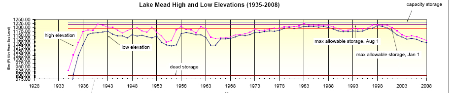
Click on the chart to see the entire image.
This post from Tom Yulsman on the Center for Environmental Journalism website paints a picture of a pretty grim future in the Colorado River watershed. When you have combined trends of steadily increasing water use with a likelihood for steadily (or is it abruptly?) decreasing river flows the outcome of dry reservoirs appears unavoidable, unless some drastic changes are made. The question is: is the Law of the River robust enough to make those drastic changes? Or do we need to scrap it and start over?
Hattip to John Fleck for pointing me to the CEJ post and providing the image above.
Subscribe to:
Posts (Atom)